
Byline – John Ford Boston Condo for Sale Broker 137 Charles St. Boston, MA
Boston Real Estate: Climate Assessment Checker for your Boston address
Boston Condos for Sale and Apartment Rentals
Boston Real Estate: Climate Assessment Checker for your Boston address
I don’t want or need to get into the politics of climate change, I just like this new climate risk assessment tool.
Check your Boston home climate risk here:
Boston Real Estate: Climate Assessment Checker for your Boston address
Climate change is impacting where people buy condominums. As the experts at the National Association of Realtors (NAR) explain:
“Sixty-three percent of people who have moved since the pandemic began say they believe climate change is—or will be—an issue in the place they currently live.”
If you’re planning to move to the Boston Waterfront or Seaport, climate change is something you might want to consider, no matter where you are.
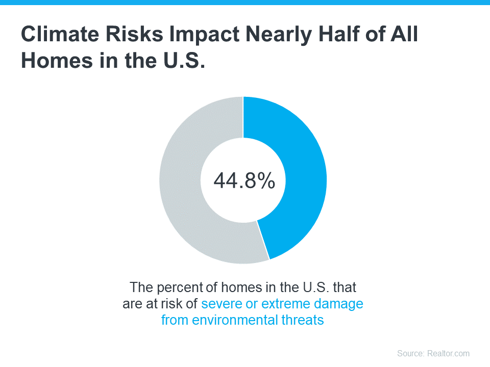
A recent study from Realtor.com helps put the growing impact climate change is having on real estate into perspective (see below):
So, how can you be sure your investment is safe from the elements?
For starters, work with a local real estate agent to understand the likelihood of your future home being exposed to hazards like wind, floods, and wildfires. Your agent will know the area and be able to tell you about the risks you’ll most likely face.
Beyond that, there are two important factors to think about: the quality of the home you want to buy and the insurance you’ll need to protect it.
Insurance To Protect It
Once you’re confident the home you’re looking at is well built, the next step is finding out what it’s going to take to insure it. As Selma Hepp, Chief Economist at CoreLogic, says:
“. . . homeowners are going to become increasingly more aware of risks of living in some areas as it becomes prohibitively expensive or very difficult to obtain hazard insurance.”
In areas where climate risks are having a bigger impact, the right home insurance can make a big difference. And the price of that insurance is an important factor when thinking about your budget and the true cost of buying and protecting your home. Get an insurance quote early in the process because you may want to compare multiple quotes and it can take several weeks to get them.
While this may feel like a lot to consider, don’t worry. An agent can help. Your real estate agent will be your go-to resource on the homebuying process, what to look for and consider, and how climate change may affect your next home. With the right planning and an agent’s expert advice, you can make this happen. Homeownership is worth it. And with a great agent by your side, you can make sure the home you find is the right fit.
Boston Condos for Sale and the Bottom Line
Climate change is an important factor to think about when buying a home. After all, your home is a huge investment, and you want to be ready for anything that might affect it. Let’s chat so you can find the perfect home.
_________________________
The increasing effects of natural disasters are leading to new obstacles in residential real estate. As a recent article from CoreLogic explains:
“As the specter of climate change looms large, the world braces for unprecedented challenges. In the world of real estate, one of those challenges will be the effects of natural catastrophes on property portfolios, homeowners, and communities.”
That may be why, according to Zillow, more and more Americans now consider how climate risks and natural disasters can impact their homeownership plans (see below):

This study goes on to explain that climate risks affect where many people look for a home. That’s because homebuyers are interested in finding out if the house they want will be exposed to things like floods, extreme heat, and wildfires.
If you’re in the same situation and are thinking about what to do next, here’s some important information to consider as you start looking for a home.
Expert Advice for Homebuyers To Reduce Climate Risks
The first thing to do is understand how to go about buying a home while thinking about climate risks. With the right help and resources, you can simplify the process.
The Mortgage Reports provides these tips for buying your next home:
- Evaluate climate risks: Before buying a home, it’s important to check if it’s in a flood-prone area using the FEMA website, review the seller’s property disclosure for any past damage, and get an inspection for issues like cracks and mold to make sure it’s a safe investment.
- Consider future preventative maintenance costs: For areas that get tropical storms, you may need to purchase hurricane shutters and sandbags to protect the home. In wildfire-prone areas, you may want to clear plants five feet from the house, consider rooftop sprinklers, or possibly buy gutter guards to prevent fire hazards. Factor these future expenses in when touring homes that may need them.
- Take steps to avoid losing your assets: Getting the right insurance for a home in a high-risk climate area is crucial. You should shop around and talk to multiple insurance agents to compare prices and options before deciding to bid on a home.
Above all else, your most valuable resource during this process is a trusted real estate expert. They’ll always focus on your goals while keeping your concerns top of mind. Even if they don’t have all the answers about how your home can handle natural disasters, they can connect you with the right experts and information.
Boston Condos Bottom Line
If you want to buy a home, but you’re also thinking about climate risks, you’re not alone. Your home is a big investment, and if anything can impact that, you want to know. Let’s connect so you have someone you can trust to guide you as you find your next home.
___________________________________________________________________________________________________
Poor neighborhoods are hotter than rich ones — especially during heat waves.
- On one afternoon in July there was at least a 7-degree difference between the South Bronx, one of the poorest neighborhoods in New York city, and the upper east side of Manhattan, one of the wealthiest.
- The data was collected.
- “There is actual data that says, ‘We breathe different air.’ There is actual data that says, ‘We see and feel heat differently than everywhere else,’” said Melissa Barber, a community activist in New York’s South Bronx.
That’s the overriding finding from the New York City component of a national project to map urban heat islands. Scientists have long known that urban areas generate heat, but until now they’ve not been able to map them street by street.
The heat trackers told a striking story. On one afternoon in July there was at least a 7-degree difference between the South Bronx, one of the poorest neighborhoods in New York city, and the Upper East Side of Manhattan, one of the wealthiest. The difference was even wider between the South Bronx and Central Park: Nearly 10 degrees.
“We are getting extremely granular data. Street-level data. What right now exists is satellite data where it’s New York City overall. It’s one weather station that covers a vast area, but what we did was we went out and measured temperature along local roads,” said Dr. Liv Yoon, a research scientist at Columbia University’s Earth Institute.
The data can help communities target their financial resources toward reducing temperatures by building more spaces, incorporating lighter colored rooftops, leaving more space between buildings and opening more cooling centers during heat waves.
Heat is the most dangerous natural hazard in cities.
Melissa Barber, a Bronx native and founder of activist organization South Bronx Unite, has fought for everything from community gardens to redesigning the Bronx waterfront to cool the area around it. Now, working with Yoon, she is using heat mapping to make a case for change to local officials and real estate developers.
“As community members who actually fight for justice, and social justice, and environmental justice, we can now say, “There is actual data that says, ‘We breathe different air.’ There is actual data that says, ‘We see and feel heat differently than everywhere else,’” said Barber.
“Historically redlined areas certainly they have less infrastructure that is conducive to cooling. They have less green spaces,” said Yoon, who spoke to CNBC one of the very few community gardens in the South Bronx — a garden Barber helped create.
Barber says data will give her more power to change real estate development across poorer parts of New York City.
“We need to really think about how we design communities. When we talk about historical injustice, and we talk about that redlining — there weren’t parks incorporated into that planning. There wasn’t water incorporated into that planning. All of the buffers that actually allow us to experience climate differently did not exist and do not exist for many of our urban communities,” said Barber.
“It’s really important because heat is one of the most insidious killers in cities. It kills more people than any other natural hazard,” said Vivek Shandas, an advisor with CAPA.
Shandas notes that climate change is upping the ante, increasing heat’s effect on local economies, which now shut down more often due to deadly heat.
“We’re seeing greater intensity of heat. We’re seeing longer durations of those heat waves, and we’re seeing more frequent heat waves come through, yet we’re still using one single number to tell us what the temperature is for a city or a region,” Shandas added.
New York is one of 12 cities participating in this year’s mapping campaign, which is in conjunction with the National Oceanic and Atmospheric Administration.
Boston Condos for Sale and Apartment Rentals
______________________________________________________________________________________________________________________________
Boston Real Estate
This content is currently unavailable. Please check back later or contact the site's support team for more information.
Boston Real Estate: Climate Assessment Checker for your Boston address
What is the climate real estate bubble?
On April 19, Time magazine published an article that tackled the issue of climate change, particularly in the way it affects (and will continue to pose a risk) on millions of homes in the U.S. This would include those Boston condos in the Seaport, Waterfront, Cape Cod ect.
Byron and Nicole weighed in on the story, sharing their thoughts on climate-induced flights, insurance, and risk mitigation tools and why people continue to buy homes in areas with high-risk weather patterns.
Boston Real Estate and the Bottom Line
I don’t want or need to get into the politics of climate change, I just like this new climate risk assessment tool.
Check your Boston home climate risk here:
Boston Condos for Sale
This content is currently unavailable. Please check back later or contact the site's support team for more information.

